

Preview
Creation Date
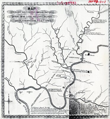
1865
Description
Top of map: MAP Embracing about 16 miles square of Cumberland Kentucky showing the oil lands and leases belonging to the Cumberland River Oil & Salt Company. 1865.
Bottom of map: In Silliman's Journal Nov 1861. Art XIII, Prof. EB Andrews of Mariella College. Ohio attributes the abundance of oil found in this district to this axis of disturbance. it having made numerous (unreadable) in which oily vapers from bituminous rocks below, could condense in the cooler rocks above and be retained.