
Description
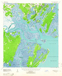
A map depicting Ossabaw Sound and the surrounding area, published by the U.S. Army Corps of Engineers in 1944.
“Ossabaw Island Quadrangle.” U.S. Army Corps of Engineers, 1944.
Recovery Date
1944
Document Type
Map
Disciplines
History | United States History
Recommended Citation
U.S. Army Corps of Engineers, "1944 USGS Map" (1944). Guarding Ossabaw Island: History and Archaeology of the 47th N.Y.V.I. Camp. 33.
https://scholarworks.moreheadstate.edu/ossabaw_island_survey/33
Files
Download
Download Full Text (9.1 MB)