
Description
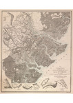
A map detailing defensive points around Savannah, Georgia and Whitemarsh Island, featuring specific illustrations of how certain defensive points were laid out, published by the Library of Congress in 1942.
Orlando M. Poe, Map Illustrating the Defence of Savannah, Ga. and the Operations Resulting in its Capture by the Army Commanded by Maj. Gen. W.T. Sherman, compiled 1880–1881, map, 55 x 50 cm, Library of Congress Geography and Map Division, Washington, DC
Recovery Date
7-31-1942
Document Type
Map
Disciplines
History | United States History
Recommended Citation
Poe, Orlando M., "Map of Savannah Defenses December 1864" (1942). Defending Savannah: History and Archaeology of the Gibson's Point Battery. 22.
https://scholarworks.moreheadstate.edu/gibson_point_battery_survey/22
Files
Download Full Text (307 KB)