
Description
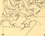
A segment of the Sketch of a part of the coast of Georgia from Savannah River to Ossabaw Sound showing the relative positions of the U.S. Iron clad steamer Montauk & the rebel Fort McAllister during the bombardment of Feb 1st 1863.
Recovery Date
2-1-1863
Document Type
Map
Disciplines
History | United States History
Recommended Citation
Boutelle, Charles O., "1863-02-01 Sketch of Georgia Coast from Savannah River to Ossabaw Sound" (1863). Guarding Ossabaw Island: History and Archaeology of the 47th N.Y.V.I. Camp. 153.
https://scholarworks.moreheadstate.edu/ossabaw_island_survey/153
Files
Download
Download Full Text (537 KB)